How to Publish Custom Basemaps to ArcGIS Online
Publishing your own custom basemaps to ArcGIS Online allows you to create map backdrops tailored to your organization’s specific needs. Whether you're working with drone imagery, scanned historical maps, or other geospatial datasets, custom basemaps help:
- Enhance the clarity of operational data
- Provide recent and localized context
- Preserve and showcase historical or cultural landscapes
Example: A tribal GIS department might publish drone imagery as a basemap to monitor land restoration, visualize culturally important areas, or support fieldwork in remote locations—far beyond what commercial basemaps offer.
This article walks you through how to publish your own custom basemap using either ArcGIS Pro or ArcGIS Online, depending on your setup.
Software requirements:
- ArcGIS Pro 3.x
- ArcGIS Online or ArcGIS Enterprise account with sharing privileges
Two Main Publishing Options
| Method | Best For | Requires ArcGIS Pro? | Analysis Ready? | Public Sharing? |
| Hosted Tile Layer | Fast display-only basemap | Yes | No | Yes |
| Hosted Imagery Layer | Preserves pixel data for analysis | No | Yes | Tiled |
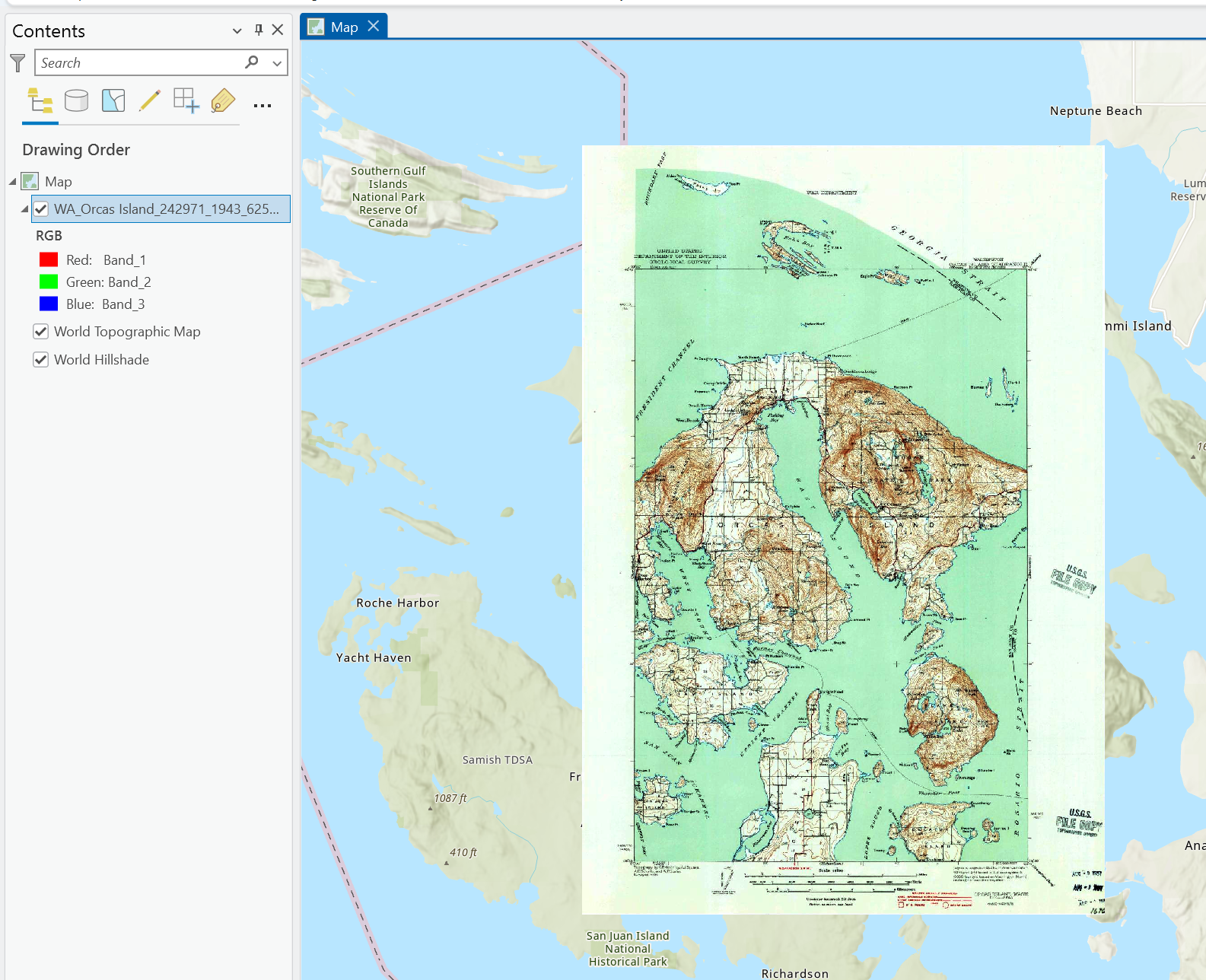
To illustrate both publishing options, we'll use a historic topographic map of Orcas Island, located in the San Juan Islands of Washington State. This map was originally produced by the U.S. Department of Interior Geological Survey in 1943 at a scale of 1:62,500 and downloaded via the USGS TopoView portal as a georeferenced GeoTIFF: https://ngmdb.usgs.gov/topoview/viewer/#4/39.98/-100.06
Why this map?
Historic USGS maps offer valuable insights into past landscapes, and make excellent custom basemaps for:
- Visualizing change over time, such as shoreline movement or land development
- Supporting environmental or tribal research with place-based context
- Enhancing map aesthetics with classic symbology and contours
Option 1: Publishing a Custom Basemap via ArcGIS Pro
This method creates a hosted tile layer, ideal for drone imagery or scanned maps that you want to use as a visual-only backdrop.
What you need:
- ArcGIS Pro connected to your ArcGIS Online account
- A georeferenced raster file
- Open Your Raster in ArcGIS Pro
- Start a new Map project
- Add your raster to the map
- Check the coordinate system: Right-click the layer > Properties > Source tab > Spatial Refence.
This 1943 map uses the Polyconic projection with the North American Datum of 1927 (NAD27) - a common standard for USGS maps of that era.
While this differs from the WGS 1984 Web Mercator Auxiliary Sphere projection used by ArcGIS Online basemaps, ArcGIS Pro will handle the transformation during publishing if the coordinate system is properly defined.
Missing or incorrect coordinate system info can cause:
- Errors during the tile publishing process
- Incorrect tiling and scale mismatch
- Poor performance when viewed in AGOL
Always check the coordinate system to ensure your raster is georeferenced, correctly aligned and ready for seamless integration in web maps. It is a simple step that prevents a lot of headaches later!
- Enable Assignment of Unique Numeric IDs
If you're preparing your map for publishing - especially when it will be used in web apps, map series, or integration with external systems - you can configure it to assign unique numeric IDs to map layers and elements.
Why Enable This?
- Ensures consistent and trackable layer IDs across sessions and exports
- Supports automation and custom scripting that reference layers by ID
- Useful in map series, labeling logic, dashboards, and geoprocessing models
This step is particularly helpful when working with multi-layer web maps or map series created from custom basemaps.
- In the Contents pane, right-click the Map or Scene (not the Layer)
- Select Properties

- Go to the General tab
- Check the box for Allow assignment of unique IDs for sharing web layers

- Click OK
- Share as a Web Layer
- Go to the Share tab
- Click Web Layer > Publish Web Layer

Under the General tab:
- Fill in Name, Summary, and Tags
- Set Layer Type to Tile
- Choose a Location. I chose my root folder.
- Choose a Sharing Level. I chose to keep it private (Owner)

Under the Configuration tab:
- For the Tiling Scheme, choose the ArcGIS Online/Bing/Google Maps tiling scheme for basemap compatibility

- Levels of Detail (LODs) for zooming control how far users can zoom in/out. Since my map is at 1:62,500 scale, I want to support viewing up to that level - but I don't need the full resolution of modern basemaps (like satellite imagery at street level):
- Minimum scale: 1:577,791 (LOD 6) - lets users view the map from regional scale
- Maximum scale: 1:36,112 (LOD 13) - close to 1:62,500 but gives a bit more detail when zoomed

- Options: I want ArcGIS Online to manage the tile caching. Also, my source is a static historic topo map - it doesn't change and can be fully cached once and served efficiently. I chose Cache automatically on the server.

Only select Cache Locally if you're managing tiles on your machine (e.g., for very large datasets or custom tiling schemes). That's more complex and rarely needed for a single historic raster.
- Click Analyze to check for errors


Note on Warnings During Analysis
When analyzing the map before publishing, you may see three warnings - this is expected in this case.
I intentionally left the World Topographic Map and World Hillshade basemaps in the map to illustrate the publishing process. As a result, the analyzer returns the following:
- "The web layer will use the WGS 1984 Web Mercator (Auxiliary Sphere) coordinate system." This is normal - ArcGIS Online uses this coordinate system by default for web maps and tile layers.
- "Layer's data source is not supported: World Topographic map."
- "Layer's data source is not supported: World Hillshade."
These warnings appear because basemap layers like Worl Topo and Hillshade aren't supported for publishing with your custom tile layer.
- Before final publishing, simply remove those two basemaps layers from the map if they are not needed in the final web layer
- Run Analyze again

- Publish the Layer
- Click Publish

- Your new tile layer is now available in Content on ArcGIS Online

- Click on Manage web layer to see the result


You can now add a Thumbnail, Description, Terms of Use, Acknowledgments...
- Use as a Basemap
- Log into your ArcGIS Online account (if necessary)
- Go to the Map tab to open Map Viewer

- In the left panel, select Basemap. Next to Current Basemap (Topographic) click on the little arrow to open the basemap's options

- In the Basemap's options select Add > Browse layers

- In My Content, select your new custom basemap > Add

- Hide or Remove the World Topographic Map and the World Hillshade

- Rename your basemap > OK


- Save your map


Option 2: Publishing a Custom Basemap Directly in ArcGIS Online
If you don’t have ArcGIS Pro, you can still publish a hosted imagery layer using ArcGIS Online (imagery hosting privileges are required).
What you need:
- ArcGIS Online account with Creator or GIS Professional user type and imagery publishing privileges.
- A single GeoTIFF or CRF file, or a collection of raster files.
- Sign in to ArcGIS Online
- Visit https://www.arcgis.com and log in
2. Upload Your Raster
- Click Content

- In My Content tab > + New item

- In the New Item window, choose to drag and drop your file or choose Imagery layer

- Choose the Imagery Layer Type
- I'll choose the Tiled Imagery Layer for public sharing and performance

Tiled Imagery Layers behave similarly to basemaps - AGOL will pre-generate image tiles at various scales. This is perfect for historic or scanned maps where:
- The imagery doesn't change
- You don't need users to adjust rendering dynamically
- Your focus is on visual context, not raster analysis
When would you choose Dynamic Imagery Layer instead?
- If you are working with multiple images (e.g., time series, mosaics)
- If you need on-the-fly rendering or image processing functions
- If you want to support tools like dynamic range adjustment, NDVI, classification, or band math
Also, keep in mind:
- Tiled Imagery Layers can be shared publicly
- Dynamic Imagery Layers are limited to your organization
- Configure and Create
- Choose a layer configuration based on your imagery. One image here.
- Click Next

- Define Imagery. Browse through your folders and files and select your raster dataset. I selected my .tif file.


- You can configure your raster's properties if needed
- Click Next
- Set the Item's details

- Click Create (bottom right)

- View item details
- Once processed, your hosted imagery layer is available in your content
- Add a thumbnail, description, terms of use, acknowledgments...
- Add it to web maps or apps like any other basemap (see steps in Option 1)

Tips for Better Results
- Simplify large rasters by clipping or resampling before upload.
- Restrict access to organizational members if the imagery is sensitive.
- Tile layers load fast but don’t support analysis.
- Imagery layers allow for rendering, pixel queries, and classification.
Creating your own custom basemap in ArcGIS Online allows you to control the visual context of your web maps, providing timely, relevant, or place-based backgrounds for your team or community. Whether using ArcGIS Pro to publish tile layers or ArcGIS Online to host imagery, the process is straightforward and opens new possibilities for how you visualize spatial data.
We hope that this article has been helpful! If you have any feedback or questions, please feel free to send us an email or connect with us for a chat. The NTGISC team is here to assist you further!